Africa4x4
African Adventure - Our Trip
Navigation

NAVIGATION
(as of 2010)
Map availability for each country varied enormously as did the accuracy and detail; few were available before we left the UK. We settled for the Tracks4africa mapping system which covers much of Africa and can be purchased and downloaded on-line and most are routable. They are very reasonably priced and the number required depends upon the country; South Africa requires four maps while other maps cover a couple of countries.
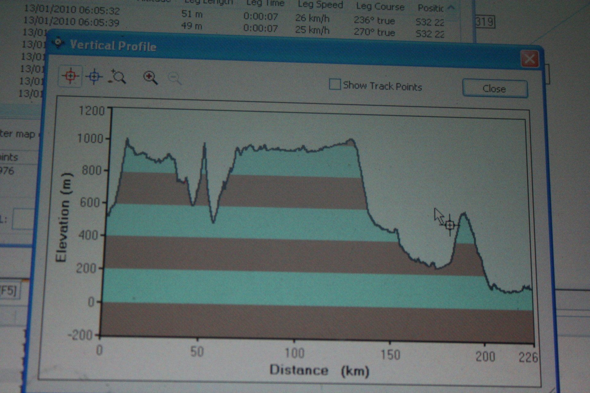
It runs through Garmin MapSource and we also ran nRoute, allowing live tracking. The package records the co-ordinates, altitude and track every few metres and waypoints can be added as one travels; handy if you have to back track. All this information is stored within the computer and we have the whole year’s worth (backed-up as well).
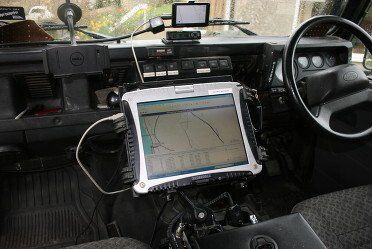
The package was loaded onto a Panasonic Toughbook CF-18 mounted on a RAM mounting bracket attached to the front cubby box, allowing the passenger to operate it. The computer was linked to a Garmin StreetPilot C330, our old one from the UK that fed our exact global position into the mapping system. This set up was ideal, particularly for off-road where the package excels as it is designed for such application: it relies upon feedback from kindred explorers to update the maps. For most of our countries the mapping was accurate and comprehensive although in some, Malawi for example, detail was lacking.
An alternative system is OziExplorer, but the disadvantage with this was it requires maps to be scanned and calibrated and really needs to be done prior to departure as it is not really feasible to do on the road in Africa. However, good maps are not available in the UK. I did set it up with large scale maps scanned in and calibrated as a back-up, but due to the size of some of the maps they would have given poor accuracy; as it was we stuck with Tracks4africa.
The Toughbook is a ruggedized computer designed for military and utility company use and it withstood 50,000 kilometres of daily pounding, vibration and dust without problem: not sure a ‘normal’ laptop would have survived. Toughbooks are very expensive new but we got an older model off e-bay, but still not cheap. The screen took a pounding with all the dust as it was always in use when travelling and consequently some parts of it were worn through constant touch screen use, but still very much usable.
Also bought a Garmin Nuvi 205 GPS in Cape Town that had roads and larger town street detail for almost all the countries we were visiting, although Tanzania coverage was poor.
I’m sure this subject has advanced since we went and will be worthy of further research.
Also very handy for navigation was one of our bird books and guidebooks. The Southern African Birdfinder Book (ISBN 1 868 72 725 4) was the basis for much of our trip, as it gave sites that are good or where rare or unusual birds occur and gives good directions to the many off-the-beaten-track locations. Covers all the countries we visited with the exception of Tanzania.
Guidebooks vary and we generally preferred the Bradt Guides as they seemed to accord more to our travel plans and give good directions to various campsites, attractions and bird and wildlife sites along with some of the birds and animals to be seen.
Whilst I did all the driving Judi was chief navigator and did an excellent job – we never fell out once over getting lost; unlike other holidays when we came close to divorce!